
Tuesday, April 2, 2013
 Travel to Warrensburg and Leeton, Missouri in search of Gwen’s family (Douglass and Perry) history. After traveling for four hours or so, we found our hotel in Warrensburg, and headed to the Leeton Museum, an almost private collection of Bob Wyatt, whose family were heavily involved in the building up of Leeton, and who now is the main keeper (curator) of the museum. Much of the material donated to the museum is from his family, but it also comes from many others in the area. The museum itself is housed in a building that is sorely in need of maintenance — insulation in the ceiling, water connections, and heating and cooling in the appropriate seasons. Bob has done a yeoman’s job organizing the material, but there is so much of it, it spills out everywhere including the entrance staircase. He also has organized the records (especially of the local school) to make available in almost yearbook fashion material on the earliest graduates (going back to the 1919 class, when the school came to a new building). This material provided us some interesting looks at Dean and Dale Douglass, who graduated in 1919 and 1922 (I think), respectively. Both were heavily involved in the school, participating in the sports and government, and other things I am sure we now have recorded (but in Gwen’s notes, not mine). In addition to letting us look at all the materials he had that related, Bob took us out to the Shiloh Church cemetery, where we got to see gravestones for Douglasses and Perry’s.

Graves at Shiloh Cemetery
Wednesday, April 3, 2013
Today, we visited the Johnson County (where Leeton is) museum from 1 until 4, as that when they are open. Lisa curates material from a number of the towns around here. She has unexpectedly been called away for the day, so wasn’t there, but one of the volunteers (Betty) was, and she was very helpful. We found the best, as in most detailed, article (written in 1934 by a guy named Ferguson) of the Douglass family that lived in the area. We also found the Johnson County census records for 1840, 50 and 60 which enabled us to place Robert Henry Douglass’ (Gwen’s great great grandfather) family as arriving in 1848-49 from Virginia. There are numerous other Douglass-named people in the 1840 census, so it is quite possible he was following in the footsteps of cousins or more distant relatives known to him at the time.
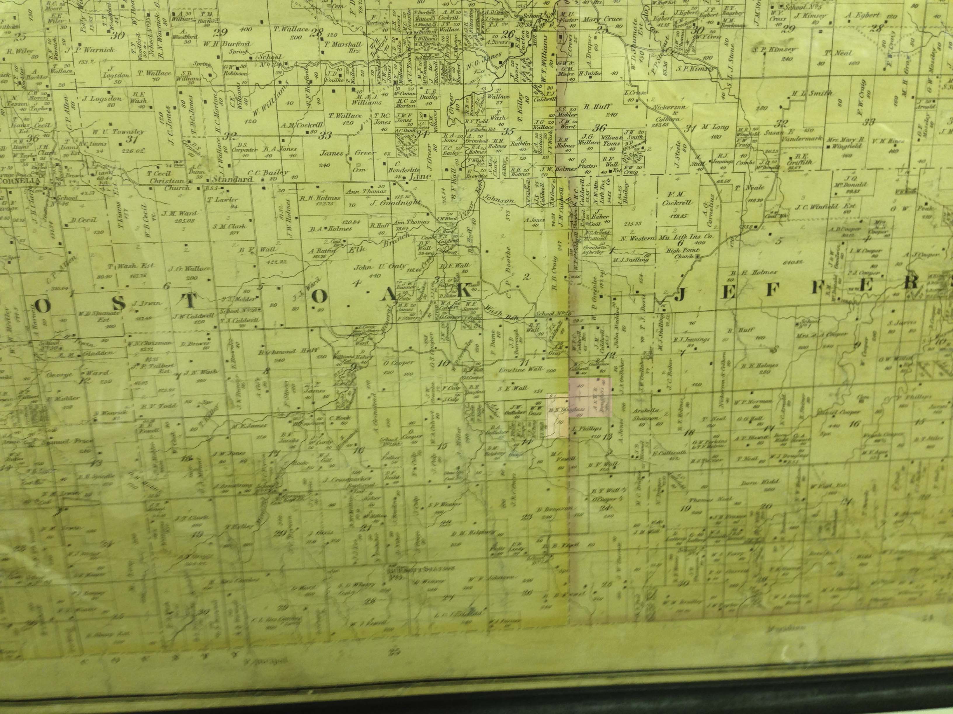
Robert Henry Douglass (and A. and T.R.). Douglass properties sit astride Jefferson and Post Oak Townships in 1870 (lightened area)
It was fun sifting through the old records. From the museum, we went to the Johnson County seat, to the Recorder’s office, and with the help of the nice women there, found land transaction records related to (Gwen’s) Douglasses. In particular, we were looking at Robert Henry Douglass, who was the one who brought his family to the area from Virginia. In 1850, a transfer of property from Robert Henry and his wife Sarah to Benjamin Holmes is recorded. I took a copy of it back to the hotel room, and as best I could, deciphered it. It was (as one would expect), written in a formulaic way, with the “party of the first part” and “party of the second part” identified and referred to, the nature of the transaction, and the detailed description of the land being transferred. Since Missouri is one of the states that was part of the Public Land Survey System set up in the late 1700s as a way to define property boundaries in the largely unexplored (at the time) areas of the North American land mass, the descriptions in the conveyance are mostly all defined using “Township, Range, Section” nomenclature. Toward the end, however, there is a parcel of land described by using a fixed corner, and then describing the boundary as if one is walking it, using a term “poles” as a unit of length measurement. It specifies the direction one walks the given number of poles, and then indicates the next direction to be taken. According to several internet sources, the “pole” is equivalent to what we might now call a “rod”, and is 16.5 feet long. The property is further proscribed by saying it was all “conveyed to me and Benjamin A. Holmes by Benjamin Snelling…” As the transaction is consummated through the exchange of $1.00, it would appear the point of it was to separate the Douglass portion of Snelling’s land sale from Holmes portion. The next day, we saw in the Johnson County museum a large land map of the county as it was in 1870, and indeed R. H. Douglass still had some 120 acres in the same area as the land described in the conveyance, so that would seem to confirm the assumption.
A fascinating detail in the record is that the Justice of the Peace who was the presiding officer for the conveyance, states he took Sarah off separately (where she was away from her husband) and explained to her the implications of the land transfer. The Justice affirms she understood the implications and agreed to the terms as explained. In glancing through a couple of other conveyances involving William J. Douglass and his wife, this action on the part of the Justice of the Peace was standard practice. I am led to wonder why this specific approach to insuring the wife understands and agrees to the conveyance independently of her husband, and the declaration of it in the recorded conveyance. There must be a story there.
Johnson County, and we assume other such rural areas, publishes (to this day) periodically what are called “Plat” maps, which are section-by-section maps showing how the land is currently divided and who owns which properties. We bought the one for 2013 as a reference.
